What’s in News?
The Centre is pushing smartphone makers to enable support for its NavIC navigation system in new devices sold in the country from next year.
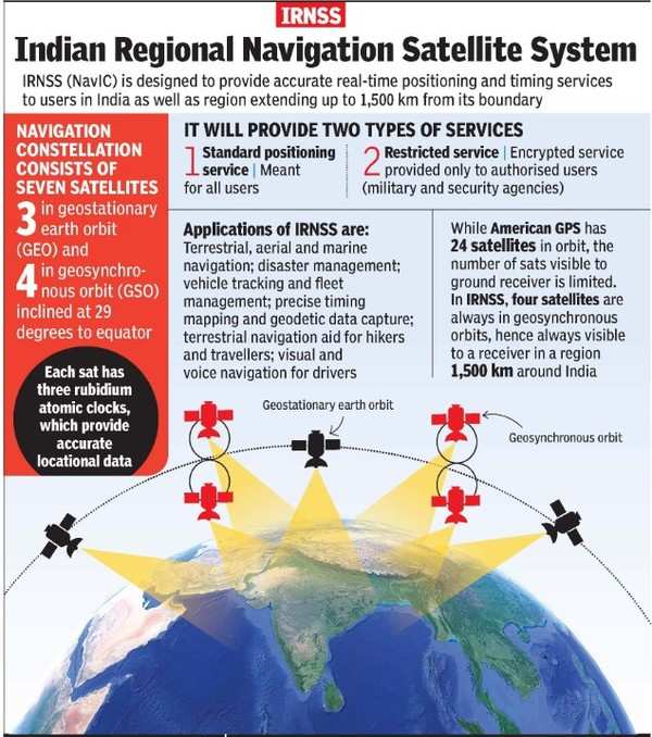
NaVIC:
- NavIC, or Navigation with Indian Constellation, is an independent stand-alone navigation satellite system developed by the Indian Space Research Organisation (ISRO).
- NavIC was originally approved in 2006 at a cost of $174 million.
- It was expected to be completed by late 2011, but only became operational in 2018
- NavIC consists of eight satellites and covers the whole of India's landmass and up to 1,500 km (930 miles) from its boundaries.
- Currently, NavIC's use is limited.
- It is being used in public vehicle tracking in India, for providing emergency warning alerts to fishermen venturing into the deep sea where there is no terrestrial network connectivity, and for tracking and providing information related to natural disasters.
Other Navigation Systems:
- GPS caters to users across the globe and its satellites circle the earth twice a day, while NavIC is currently for use in India and adjacent areas.
- Like GPS, there are three more navigation systems that have global coverage—Galileo from the European Union, Russia-owned GLONASS and China's Beidou.
- QZSS, operated by Japan, is another regional navigation system covering Asia-Oceania region, with a focus on Japan.
Reasons for the move:
- Conceived to reduce dependence on foreign navigation systems, NavIC is an indigenous positioning system under Indian control.
- There is no risk of the service being withdrawn or denied in a given situation.
- Whereas relying on systems like GPS and GLONASS might not always be reliable as they are operated by the defence agencies of the respective nations.
- Relying on systems like GPS might also compromise India’s strategic defence moves and there are chances of further exposing civilian data.
- This also helps to promote local industry engaged in developing indigenous NavIC-based solutions.
- NavIC is as good as GPS of the United States in terms of position accuracy, so it doesnot make much difference to the users
Challenges:
- This would add to cost as it requires research, hardware design changes and additional investments to support devices specific to India
- At present, only a few chipsets that support NavIC technology
- NavIC uses L5 frequency, whereas GPS uses L1 satellite frequency, so it easier for manufacturers to integrate NavIC in chipsets which mostly support the L1 band the world over, curbing separate development costs for NavIC.
- But NavIC was likely to be available on the L1 band only by 2024-25, after more satellite launches.
 UPSC - 2027 - Prelims cum Mains - New Batch Starts on 24-06-2026